Destination: Owikeno Lake Area Tour
Route Briefing
- This Scenery is for "Return to Misty Moorings" only.
- Suggested Altitude: Varies with Leg
- Landing zone is: Varies with leg
- GPS for Start Point: N51 57.74 - W126 40.30
- Distance approximately: 134 Miles
- Download PRINT-ABLE copy HERE
- Flight-Seeing Flight Plan & Map HERE
- Scenery Needed: PNW, PFJ, Owikeno Lake
Owikeno Lake Area Tour
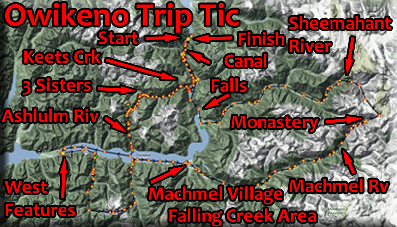
This is a trip ticket for a tour of the entire Owikeno Lake Scenery Area. To see a full overview of this area, click here. We will start at Pacific Fjords Gateway Airport and fly to all of the scenery locations, returning to the airport. You will have to alter altitude for various legs of this trip. Pictures of the locations are in the overview document. Pictures added below will be for navigational purposes.
NOTAM Some legs are very short, you will not have time in the air to read them and react as you should. Read each leg's instructions FIRST, then fly the leg. Also, this is an "Expert" Trip Ticket ... you should have a lot of experience before attempting all that is here. Again, read each leg ahead carefully.
WaveTop & TreeTop VFR Plan
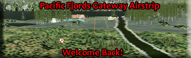
FROM : Pacific Fjords Gateway Airstrip (PF50)
TO: Pacific Fjords Gateway Airstrip (Round trip)
Leg: PFG Airstrip to PFG Canal Cabin 1
Initial Course: 197
Leg Distance: 1.3 Miles
Leg Altitude: 400 Feet
This is a very short hop, only 1.3 miles. Stay in landing configuration and stay at about 400 feet in elevation. you will follow the canal and when this leg of it ends in a lake, you will turn to port into the lake. The cabin is nearby on the port shore. Land and look around at the view, the waterfall is amazing.
REMINDER: Read the next leg before attempting.
Leg: PFG Canal Cabin 1 to PFG Cabin 2
Initial Course: 179
Leg Distance: 1 Mile
Leg Altitude: 400 Feet

Another very short leg. take off on a 179 heading toward the waterfall and stay in landing configuration and "wave top" altitude. Alter your heading a little to port to follow the port shoreline. You will pass over the "1st connector canal" (very short) connecting to a little lake beyond. Beyond the little lake, there is a 2nd connector canal and the cabin is just beyond on the shoreline. Try to land either in the second connector canal or just beyond, this is a SHORT landing zone. (Watch for a sailboat in the small lake).
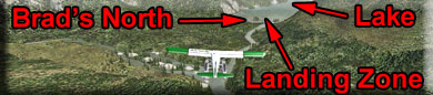
Leg: PFG Cabin 2 to Brads BBQ North
Initial Course: 206
Leg Distance: 5.8 Miles
Leg Altitude: 800 Feet
Take off on a heading of about 206, a safe altitude for this leg is 800 feet. You will again fly over the canal for about a half mile. At the end of the canal you will see the Canal Control Station. At the Control Station, you will turn to port and follow the river. As you approach the lake, go into landing configuration and plan on bank to port for the approach to Brad's BBQ North.
Leg: Brad's North to Keet's Creek Cabin
Initial Course: 192
Leg Distance: 3 miles
Leg Altitude: Wavetop
Take off from Brad's on a 192 course and land ahead at a point with red tents. Land well-ahead of this point because you are going to be taxiing up the little river there to the keet's Creek Cabin, about 1 mile away.
Leg: Keet's Creek Cabin to Little Sister Cabin
Initial Course: 295
Leg Distance: 8 Miles
Leg Altitude: 2900 Feet
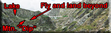
You will be taking off toward the waterfall on a course of about 295. You may feel safer to taxi back out the river and get a longer takeoff zone. Fly between the cliffs there passing the waterfall. The river turns to port, follow the river until it makes a sharp bend to port and a DRY VALLEY appears going straight. You will fly up the dry valley. You must have 2900 feet of altitude to land on this next lake.
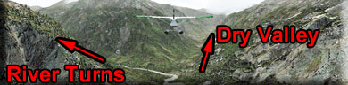
About 2.5 miles after the river turns to port, you will see a turn to port ahead, but before that a slight "dip" in the mountain at 11 o'clock. The Lake you are seeking is just past that rise. Fly over the dip in landing configuration, bank to port and land. The cabin is ahead to port.
NOTAM: VERY SMALL LANDING ZONE - FULL FLAPS
Leg: Little Sister Cabin to Middle Sister Cabin
Initial Course: 171
Leg Distance: 1.5 Miles
Leg Altitude: 3200 feet
Taxi to the OPPOSITE side of the lake from the cabin. Take off on a heading of 171, flying over the cabin. The valley ahead bends to starboard and rises. As you come to the lake, be in landing configuration. The cabin will be on the far shore ahead of you.
NOTAM: This is a very SHORT landing zone!!
Leg: Middle Sister Cabin to Big Sister Cabin
Initial Course: 192
Leg Distance: 1 mile
Leg Altitude: 3500 Feet
take off from the opposite side of the lake from the cabin and take off over the cabin. As you go over the edge of the mountain, begin to turn to starboard and climb to 3500 feet. Watch for 2 waterfalls on the cliff to starboard. your landing zone is just behind the top waterfall where you will fly over Big Sister Cabin to land in the lake.
Leg: Big Sister Cabin to Brad's BBQ Ashlulm Creek
Initial Course: 122
Leg Distance: 3 Miles
Leg Altitude: 800 feet over the river to land
Take off from the opposite side of the lake from the cabin on a heading of 122. Over the edge of the cliff, turn to starboard to follow the valley there. Lose altitude to 1200 feet (full flaps and little power). When the valley branches, take the port branch, (the one going down, not up). You will find the Ashlulm River there.
You will pass over Ashlulm Creek Lodge. If you have a very small and agile aircraft (or a helicopter) you can land there, but it is not recommended for most floats and amphibs.
Continue to fly down Ashlulm Creek to its outfall to Owikeno Lake about 4 miles ahead. As you approach the lake, go into landing configuration and be prepared to land. Brad's BBQ is on the starboard shore point of the Ashlulm River.
Leg: Brad's BBQ Ashlulm Creek to Owikeno Resort
Initial Course: 186 - then right center of the lake
Leg Distance: 20 Miles
Leg Altitude: 1000 Feet
Take off from Brad's toward the starboard point on a heading of 186. Once airborne, turn to starboard to fly down the right center of the lake. You will be going to the end of the starboard shore. You will find the Resort and Casino there and can land out in front of the marina.
NOTAM: Watch for active marine traffic in this area. There is a transportation boat that docks to the starboard side of the Resort and goes between the Casino and Machmel Village.
Leg: Owikeno Resort to Owikeno West Airstrip
Initial Course: 205
Leg Distance: 1 Mile
Leg Altitude: 800 feet
IF you look in the direction of 205, you will see Brad's BBQ West on the far shore. Fly toward that waypoint. Once airborne, you will see the airstrip to port. Go into landing configuration and land at the little airport.
When you have seen the airport, turn around on the runway to a heading of 070 and prepare for takeoff.
Leg: Owikeno West Airstrip to West Fishing Village
Initial Course: 070.
Leg Distance: 2 miles
Leg Altitude: "wavetop"
We are going to take off from the airport, but hold landing configuration and low speed, we are going to land in the water just beyond the shore and taxi to Brad's BBQ to starboard.
NOTAM, be sure to raise landing gear quickly after takeoff as you will land just beyond the runway in the water.
Taxi over to Brad's BBQ West, check it out, then continue to taxi about 180 to the Ferry Dock ahead. You'll see it has an extensive parking lot and facilities.
NOTAM: Watch out for the Ferry Boat, it docks here every hour and a half (and it is bigger than you are!).
Taxi past the ferry dock and turn a little to port on a heading of 250 to take a look at the West Fishing Village. It is a fairly extensive little community.
NOTAM: Watch for "the Captain's" boat ... it docks here at the village and (later) back at his cabin every 2 hours.
Leg: W. Fishing Village to Dallory's Cabin
Initial Course: 055
Leg Distance: 5 Miles
Leg Altitude: 800 Feet
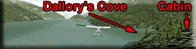
In front of the fishing village, line up on a 055 heading. We will be flying the starboard shore of the lake for 5 miles to dallory's Cabin. Watch for Dallory's Cove to show up to starboard and fly into it. The cabin will be ahead at 2 o'clock.
Leg: Dallary's Cabin to Dallary End Cabin
Initial Course: Taxi 345, turn 180 take about 195
Leg Distance: 5 Miles
Leg Altitude: 800 Feet
From the dock, taxi on a 345 heading about a mile off shore, then turn around for an approximate heading of 195. You should be looking at a river outfall. Take off and head over the outfall of the river there. Maintain altitude of about 1200 feet on this 5 mile leg to your destination. You will be using the river as your guide.
NOTAM: Unless you have a lightweight aircraft, you will never get back up from these two landing zones ahead. It may be best to fly over them and continue ahead.
There are two short landing zones, each with a cabin showing. Be very careful to have your speed and configuration correct. If you are not comfortable with the landing zone, then don't land, continue flying to the next waypoint.
Leg: Dallary End Cabin to Falling Creek Lower Cabin
Initial Course: 195
Leg Distance: 6 Miles
Leg Altitude: 3300 Feet
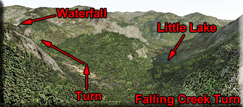
Start climbing quickly to 3300 Feet. As you continue down the valley past Dallary End Cabin, the canyon branches, take the port branch ... continue climbing. The turn is difficult to spot. Watch for a little lake, you will turn ahead of that. Once you start making the turn, as you come around the mountain, you will see a waterfall in the distance. That waterfall is falling from the lower lake, you will land ABOVE that waterfall. The Lake's altitude is 3100 Feet. Fly over the waterfall and follow the "S" shaped lake to the end, the cabin will be on the shore at 11 o'clock.
Leg: Lower Falling Creek to Upper Falling Creek Cabin
Initial Course: 244
Leg Distance: 5 Miles
Leg Altitude: 4200 Feet
Line up to fly away from the Lower Falling Creek Cabin down the lake toward the first waterfall you saw. After you take off, begin to gain altitude. When you come to the end of the lake, do a 180 and go back toward the high waterfall ... continuing to gain altitude until you are at 4200 feet. Fly over the high set of waterfalls and land just beyond the cabin perched on the near shore.
Leg: Upper Falling Creek Cabin to Doos Creek Cabin
Initial Course: 240
Leg Distance: 10 Miles
Leg Altitude: 6100 Feet
Taxi to the far end of the lake AWAY from the cabin. At the end of the lake, turn around and head back toward the cabin. Roughly 240 degrees. You are going to fly over the cabin and out over Lower Falling Creek Lake. About half way down the lake, do another 180 and fly back over the double waterfalls gaining altitude to 6100 feet. Look for the snow capped mountain, you will be flying just to starboard of that peak at 6100 feet.
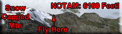
When you pass over that ridge, be ready to cut power and literally dive to the valley below. (This is a breathtaking view!). When you get down to the valley, turn to port following the valley.
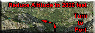
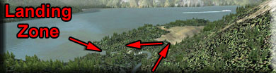
Stay about 1000 feet over Doos Creek. As you near the lake, go into landing configuration ... very slow. Follow the creek's turn to starboard then fly to port over the waterfall and land in front of the cabin.
Leg: Doos Creek Cabin to Captain's Cabin
Initial Course: 075
Leg Distance: 8 Miles
Leg Altitude: 800 Feet
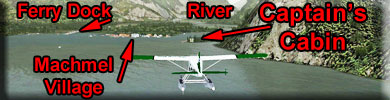
Taxi out into the lake and turn to a heading of about 075 and take off. Maintain altitude at about 800 feet, you will be landing again in 8 miles at the Captain's Cabin.
As you approach the end of the lake, on the shoreline there are some key features. The Captains Cabin, your destination, is to starboard. The Machmel River is straight ahead. Machmel Village is in the center and the Ferry and Transportation docks are to port along the shoreline. You will land near the Captains Cabin.
NOTAM: Watch for marine traffic in this area. The Captains Trawler parks at the Captain's Cabin. The Ferry docks at the Ferry Dock and the Megayacht from the Casino docks at the Transportation dock furthest to port.
Leg: Captain's Cabin to Machmel Village and Ferry Dock
Initial Course: 060
Leg Distance: 2 Miles
Leg Altitude: Taxi on Water
When at the dock of the Captain's Cabin, set a heading of 060 and taxi over to the shore along Machmel Village. Continue past the village and check out the Ferry and transportation docks.
(If you see the Ferry Coming, stick around and watch it dock, the captain of the ferry never makes a mistake!)
Leg: Machmel Village to Canyon Cabin
Initial Course: 095 (Follow the River)
Leg Distance: 10 Miles
Leg Altitude: 1700 Feet (safe) 1100 Feet (dangerous)
Taxi away from the Ferry Dock on a heading of about 270. Go out about a mile. You are then going to turn around about 180 degrees and take off toward Machmel Village, flying over it and heading up the Machmel River.
NOTAM: Watch for River Buoys that mark the route for boats, you can follow those buoys also.
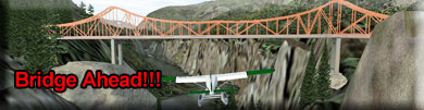
The river stays in a deep canyon and will eventually bend to port. You will see a deep canyon coming in from starboard. At that junction is Canyon Cabin. Helicopters can land there and some VERY SMALL planes can make it also, but it is a dangerous approach and landing, so if in doubt, continue flying over it to the next waypoint. The canyon upper ledges are about 1100 feet ... if you fly there you can get a good look as you fly over, and maybe attempt to go under the bridge!
(Notice the suspension bridge! ... "Some" have flown under it! You must be at about 1000 feet or less to accomplish it!)
Leg: Canyon Cabin to Falls and Falls Cabin
Initial Course: Follow the River
Leg Distance: 5 Miles
Leg Altitude: 1200 Feet or more
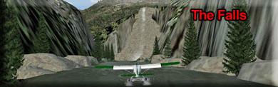
You will see a place where the canyon looks like it is going to end, and there is a straight and fairly wide river there. You can land there, then taxi ahead to the waterfall and cabin. This gives you a "feel" for what the "River Run" for the Machmel River is like. It's a pleasant taxi, and a safe way to see the falls and cabin. Taxi to the cabin. (Or fly over this and follow the river if you do not want to attempt a landing!) You will need a light weight aircraft to attempt this.
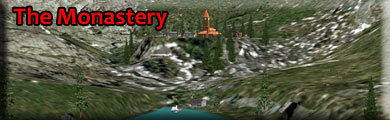
Leg: Falls Cabin to The Monastery
Initial Course: Follow the River
Leg Distance: 17 Miles
Leg Altitude: Increasing to 3500 Feet
NOTAM: If you are going to over fly the monastery using the gps, set your altitude for 9200 feet!
Your landing zone will be at 3375 feet in altitude. You will see the end of the river coming with a high, snow-capped mountain behind it. The Monetary is positioned in front of the mountain. Land on the lake ahead and taxi up to the dock there. (Get out and check out the Monastery if you like...slew).
Leg: Monastery to Sheemahant Lake Cabin
Initial Course: 221
Leg Distance: 8 Miles
Leg Altitude: 9200(NOTAM: High Altitude Needed)
NOTAM: You must use GPS for this leg, there are no good VFR waypoints for sighting. Also, you must be at significant altitude, so if the weather is not clear, do not attempt this leg. (Stay over at the Monastery and enjoy the brandy!).
You will take off heading AWAY from the Monetary on a rough heading of 221. You need an altitude of 9175 to safely cross over the peak behind the Monetary. So fly between the mountains back down the river climbing until you are at about 4500 feet. Then you do a "U" turn to a rough heading of roughly 53 degrees, staying again between the mountains. You will fly to the top of the glacier behind the monetary. The safe altitude there is 9200 feet.
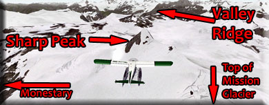
Get onto the GPS track (included in trip ticket) and continue climbing to 9200 feet. Follow the GPS track. You will see the GPS turn you to 300 degrees. Look for a sharp peak to port. You should be on a heading of 300 headed toward the sharp peak, the valley ridge is just beyond, but you won't see the valley till you cross over the ridge.

Once you cross over Valley Ridge, you will see the Upper Sheemahant lake ahead at an altitude of 2300 feet. Cross over the lake at about 5000 feet. The valley turns to port, follow it and continue to descend. Your landing zone is 3.8 miles ahead. The valley leads you to Sheemahant Lake.
As you approach the lake, the cabin will be to the near starboard shore of the lake.
- If you got this far, it might be time for a break. That was the most difficult leg of the trip, from here to the end, it is good VFR flying with good waypoints and beautiful scenery.
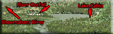
Leg: Sheemahant Lake Cabin to Owikeno North Airstrip
Initial Course: 182
Leg Distance: 25 Miles
Leg Altitude: 1600 Feet
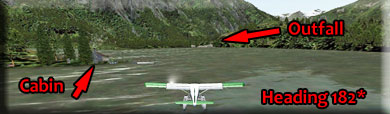
Taxi to the western shore of the lake and turn around heading for the outfall to a heading of 182 for a SHORT takeoff. Then begin following the beautiful Sheemahant River. The river is about 25 miles long and very wide and easy to follow.
-
The Sheemahant River is a stream located just 26.9 miles from Rivers Inlet, in the province of British Columbia, Canada. Fishermen will find a variety of fish including rainbow trout, cutthroat trout and bull trout here. Whether you’re spinning, fly fishing or baitcasting your chances of getting a bite here are good. So grab your favorite fly fishing rod and reel, and head out to Sheemahant River. If all goes well, the rainbow will be hooked by your crustaceans, the bull will be biting your minnows and the apache trout will be grabbing your worms.
As you approach the outfall of the Sheemahant River to Owikeno Lake, you will see the Owikeno North Airstrip ahead, you can land and check out the little farm on the peninsula to the south of the airstrip. Fly out over the lake and make a slow turn to port lowering altitude to line up on the runway and come in over the little farm.
Leg: Owikeno North Airstrip to PFJ Gateway Airstrip
Initial Course: 328
Leg Distance: 14 Miles
Leg Altitude: 1200 Feet
Take of on "33" on a rough heading of 328. Follow the starboard shoreline and it will lead you to the 3rd Narrows. Once through the narrows, you'll see the Keet's Creek waterfalls to port and the Brad's BBQ North on the northern shore of the lake. Stay to starboard in the valley and you will get a quick glimpse of Wuikinuvx Falls ... not accessible by fixed wing aircraft. Continue on up the river and turn to port over the PFJ Canal Gateway station. Follow the canal and as you reach the lake area, reduce altitude, you will be landing at the Pacific Fjords Gateway Airstrip 3 miles ahead.